
|
The Jedi were real? This article is part of the history of Clan Odan-Urr and isn't part of current events.
Please do not remove this tag or the contents. These articles exist for historic purposes.
|
|
| New Tython (Harakoa)
|
|
Outer Rim Territories
|
|
Esstran sector
|
|
DLSCX-2298 (Yhi System)
|
|
1: Yhi
|
|
2: Iah, Kalfu
|
|
1.1 AU
|
|
389 Standard Days
|
|
Terrestrial
|
|
9,645 km
|
|
Type I
|
|
-20 to 48˚C
|
|
1.23 x Standard
|
|
Variable
|
|
|
|
Harakoans
|
|
Humans, Mon Calamari, Various Species
|
|
Basic, Harakose
|
- ~100,000 Human Colonists
- ~50,000 Mon Calamari Colonists
- ~12,000 Bothan Colonists
- ~300,000,000 Natives
|
|
Menat Ombo, Dac Compound
|
|
None
|
|
None
|
|
Odan-Urr
|
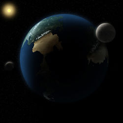
New Tython, known as Harakoa to the indigenous population, is the home planet of House Odan-Urr. Once a world of tribal and colonial strife, it fell in late 36 ABY to the Thuron Monarchy before being liberated by the Jedi. Today it exists as a planet of peace, where nations strive together toward a better and brighter future - without the abandonment of the planet's rich heritage.
Please bear with the Odan-Urr Summit while we work on updates to this page. Thank you!
History
This section is in the shipyards for repair. Check back soon!
Nations and Territories
This section is in the shipyards for repair. Check back soon!
Geography
There are four continents on New Tython; ranging from the gigantic continent of Owyhyee in the North West Hemisphere, which has a wide range of different climates (including deserts and grassy plains), to the smallest continent of Sanulu covered in mountain ranges peppered by dozens of semi-active volcanoes, resulting in the region being christened "The Inferno" by the various native populations.
Apart from Owyhyee and Sanulu, there are the two other continents of Kamuekiko and Milil’ea, as well as various islands spread across the oceans of the planet. One such grouping of islands approximately 250 kilometers off the west coast of Sanulu has never been colonized by native or immigrant populations, owing primarily to the fact that they are composed almost entirely of volcanic rock and glass and have no native wildlife upon them.
Owyhyee
(pronounced: "O-wih-hee-ay")
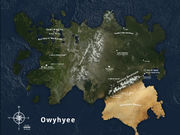 Owyhyee
Owyhyee is situated in the North West Hemisphere and is 3,720 miles from east coast to west coast, and 2,950 miles from north coast to south coast. It is sparsely populated, encouraging a nomadic lifestyle, though it also houses the Colonial seat of government, Menat Ombo. The capital is situated on the banks of the vast, turbulent River Sabina, which is prone to seasonal flooding, and eventually flows into the Bythic Ocean.
The vast grasslands of Owyhyee is home to countless species of both flora and fauna. Vast herds of beasts which the natives hunt for food and clothing support approximately 100.000.000 indigenous people divided into thousands of small communities. Several major rivers flow across the continent, some stretching it breadth, fueled by countless snow melt tributaries nestled deep in the continent's central mountain range, the second largest on New Tython. The grasslands in the east of the continent are split from the Honunom desert by a mountain chain that reaches an average height of up to four kilometers. The vast height of the mountains discourages the natives from passing over them, however notable villages in the primary passes to the Honunom desert command trade through the region. The city of Tanduran is the main trading hub on the eastern preries, connected via road and sky with Menat Ombo and the City of Seher on the southeastern coast. Seher, while being a predominantly native city, is still very well connected with the colonies.
The Honunom desert reaches a max temperature of 48 degrees Celsius during the day in summer, but is prone to plunging well below freezing at night. Life is sparse in the desert, as is water, but there are several dozen oases spread across the desert where they tap into the deep water table. The Melewati desert tribe and several Harakoan tribes populate this desert. Travelers mostly avoid the ruins of the once large prison facility, Purity Rock. A testament to a darker age.
Kamuekiko
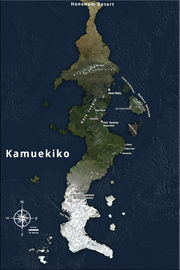 Kamuekiko
(pronounced: "Ka-mue-kee-ko")
Situated directly South of Owyhyee, Kamuekiko is attached to the Northern continent by a narrow isthmus of desertified land and savanna which tapers into a mountain range in the north. Most of the rest of the continent is covered in tropical and temperate forests, though the far south is permafrost and tundra, with only the extreme south permanently covered in an icecap. Despite the relative geological calmness, there are occasional earthquakes across the whole continent, especially in the north where the Owyhyeean and Kamuekikan tectonic plates converge and form the Blue mountains. The coasts have many natural (including some deep water) harbors.
The isthmus between Owyhyee and Kamuekiko is part of the Honunom desert, which often discourages migration between the two continents. However several tribes from the Hononum region do travel south in the winter months when the temperatures fall, to trade goods with the natives in the Blue mountains. South of the mountains, on the eastern coast, lies the insular city of Vard Mislu. Further south is Fort Pernicar, the home of House Hoth and the training grounds of many of the KUDF's elite commandos. Further east from Pernicar is the Bahari island chain, home to the Iwu Kisiwa Makazi tribes. Many more tribes and tribal alliances live in the surrounding forests. The farthest south near the south pole, the Iwu Tohora make their home on the frozen icebergs of Crescent bay.
Kamuekiko is a narrow continent, but quite long, stretching down to south pole. This is the cause of the extremely cold weather in winter. The continent measures 3,164 miles from the isthmus between Owyhyee and Kamuekiko to the southern tip. From the east to west coasts, it measures only 800 miles at the widest point. Off the west coast of Kamuekiko lays an archipelago, consisting of hundreds of tiny islands.
Milil’ea
(pronounced: "Me-lil-ee-ah")
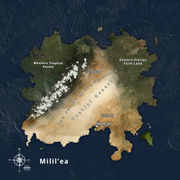 Milil'ea
Milil'ea is the second largest continent of New Tython. It's climate ranges from tropical in the south, to dry arid tundra in the north and temperate in the east and west. The north-west of Milil'ea is covered with lush forests and grasslands, lively with creatures of all sorts and protected from the arid desert by a chain of massive, tall mountains. These mountain peaks are the largest and tallest on new Tython, some reaching heights of up to ten kilometers. While the west if fairly lush, and often wet, the east is covered with temperate savanna and preries. Farthest east are farmlands inhabited by different Harakoan tribes.
Dominating the vast continent is the Central desert region, also called Koraha Mahue by the natives. This vast expanse of land holds many danges for the unwary traveler and contains as many different terrains as it does species of flora and fauna. The north of the region is covered in unending sand dunes, liquid sand and deadly sandstorms. Freak tornadoes and dust devils are frequent. Most natives avoid these areas, though with the right equipment one might survive long enough to traverse the expanse and find shelter in the mountains.
The south of the desert is mostly rocky, though still covered with sand carried from the north. On the eastern slopes of the mountains, a vast expanse of natural geysers spewing large quantities of heglum gas. These natural phenomena occurred due to tectonic activity deep beneath the mountains. Natives use these gasses to lift their flying dirigibles and traverse the rocky crevasses around the feet of the mountains. Most of Milil'ea's desert natives live in the arid wastes of the south, protected from the deadly sandstorms.
The sun is blistering in most of the desert due to the composition of the sand. Temperatures rise to an average 50 degrees standard during the day, and fall well under freezing at night. Travelers must always cover their whole body, due to easy sunburn and deadly diseases that accompany this condition. The desert region is inhabited by the Iwu Koraha Mahue, the people of the lost desert.
Milil'ea is 2,670 miles from north to south at its widest point, while it measures 2,540 miles from east to west, a truly vast continent.
Sanulu
(pronounced: “San-u-lu")
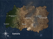 Sanulu
Situated in the North Eastern Hemisphere of New Tython, Sanulu is the smallest of the four continents of New Tython, consisting of an extreme climate due to the constantly erupting volcano-networks permeating its rugged geography. The constant flow of lava increases the size of the continental shelf by up to a mile per year (depending on yearly flow-size). Due to the ash thrown up into the atmosphere, the air above the interior of the continent is high in nitrogen and carbon dioxide making it unsuitable for sentient habitation, though there are minor settlements on the more temperate and geologically calmer coastlines.
Sanulu is home to a large community of Mon Calamari who live in the aptly named Dac Compound on it's western coast. The compound is situated some six miles from teh coast itself, on an artificial archipelago built exclusively to harbor the small community.
Sanulu is small in size compared to the other three continents, measuring 1,930 miles from its east to west coast and 1,169 miles from its north to south coast. However, it is growing each year. It is calculated that if it continues to grow in size at its current pace, the continent will rival Milil'ea in size in approximately 300,000 years time.
It is speculated that Sanulu was once the site of a vast Harakoan empire, known only as the Maia'toa. Little is known about them and excavations into the hazardous zone are ill advised and dangerous due to tectonic activity.
Treaty of Menat Ombo
Political Landscape
Economy